
We are pleased to announce the publication of the new dedicated Level-4 SMOS Sea Surface Salinity (SSS) product (and its uncertainty) for the Southern Ocean with an unprecedented 6.25 km resolution. This new development was carried out within the framework of the H2020 EU CRiceS project (AO/1 −10461/20/ I−NB, grant no. 101003826).
.
The new product has the following specifications:
| Geographical coverage | 180◦ W – 180◦ E; 30◦ S – 90◦ S |
| Temporal coverage | 2011-02-01 to 2023-03-31 |
| Spatial resolution | 6.25km x 6.25km |
| Coordinates reference | EASE-SL 6.25km |
| Temporal resolution | Daily |
| DOI | https://doi.org/10.20350/digitalCSIC/17709 |
What is this new product?
The product is created by fusing:
- SMOS SOFRESH Level-3 SSS data (https://doi.org/10.20350/digitalCSIC/15493)
- MUR SST daily fields
This multiscale fusion method allows us to resolve much finer ocean structures than SMOS alone following the methodology described in Umbert et al. [2014] and Olmedo et al. [2016].
The MUR SST product (Chin et al. [2017]) from the JPL MUR MEaSUREs Project is used for the template in the fusion algorithm. This product provides a Level-4 Global Foundation Sea Surface Temperature Analysis. This SST product is originally provided at a resolution of 0.01º × 0.01º . Therefore, before applying the fusion algorithm, we performed a regridding to the final EASE grid at 6.25 km × 6.25 km.
Validation assessment
Validation has been performed against many in situ datasets by using the Pi-MEP platform. The statistics reveal clear differences in performance across the various in situ platforms. Argo exhibits the lowest dispersion (Std = 0.18 psu, RMS = 0.18 psu) and the highest R2 (0.40), confirming it as the most consistent reference for SMOS, with negligible median and mean differences. Marine mammals show similarly small biases (Median = 0.00 psu), but slightly higher dispersion (Std = 0.25 psu) and lower correlation (R2= 0.08), reflecting their operation in dynamically active frontal regions. See figures 1 and 2 below.
Why does it matter?
The Southern Ocean plays a key role in global climate, ocean circulation, and atmosphere– ocean exchanges. High-resolution SSS helps to:
- Identify freshwater inputs and mixing
- Improve ocean and climate model validation
- Resolve small-scale fronts and filaments
The new L4 SSS Southern Ocean product represents an important step forward in observing salinity at high resolution in a region where data are scarce. It will support research on ocean dynamics, sea-ice interactions, and climate processes.Data is freely available at BEC Data system and open to users in secure ftp (sftp) service in bec.icm.csic.es/data-access-ftp/.
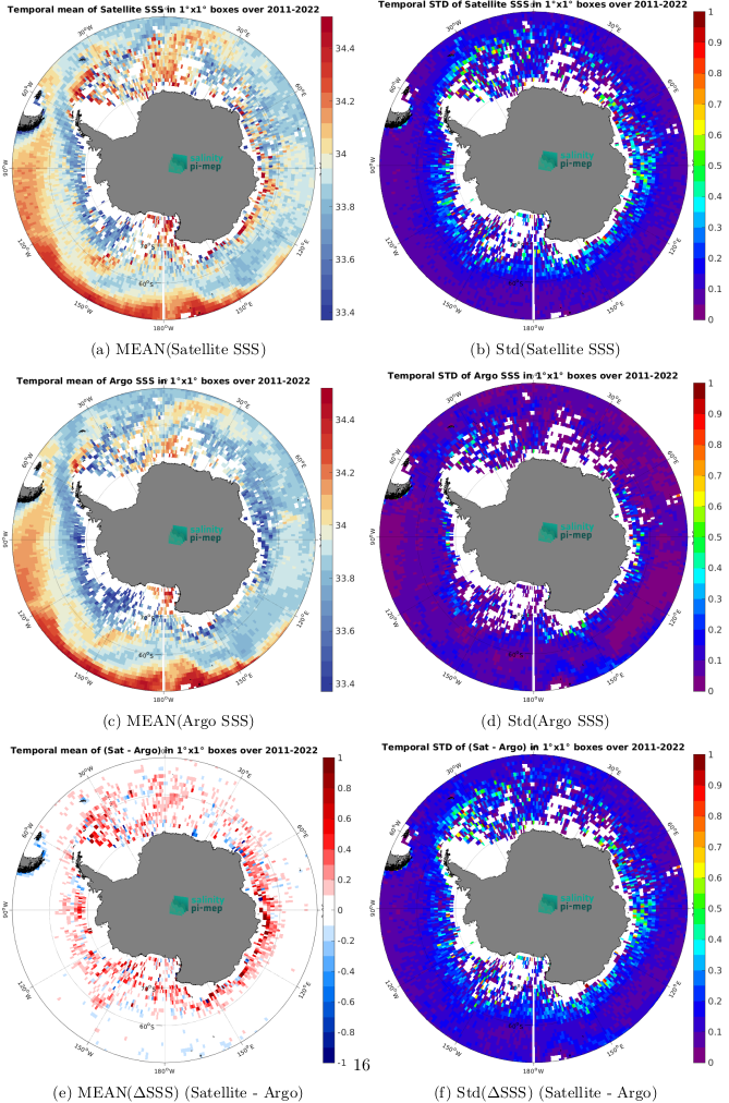
Figure 1: Validation statistics against ARGO floats data
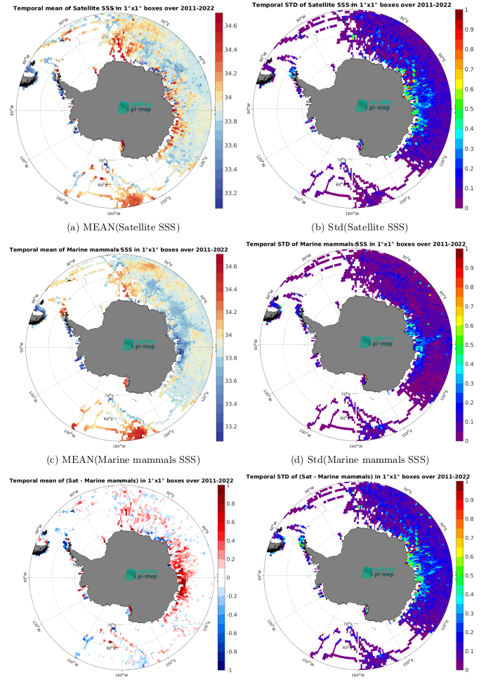
Figure 2: Validation statistics against Marine Mammals CTD measurements